 Français (France)
 English (UK)
 English (US)
 Deutsch (Deutschland)

Contents
The plateau is perfectly clear at the start. Then fog climbs out of the valley, the cairn across the way disappears, and the faint trail fades into the short grass. That’s when the compass stops being a gadget at the bottom of your backpack and becomes the most useful thing you carry, as long as you learned to use it before you needed it.
Ordnance Survey, Britain’s national mapping agency, puts it plainly: phones and mapping apps are hugely useful, but batteries die and signal drops, while a compass works anywhere [1]. It doesn’t replace the map, it completes it: the map tells you where to go, the compass tells you which way.
A hiking compass, part by part
The baseplate compass hikers use comes down to five parts [1]. The clear baseplate, whose straight edge works as a ruler between two points. The magnetized needle, whose red end points to magnetic north. The rotating dial, or bezel, marked from 0 to 360°. The orienting lines and arrow at the bottom of the housing, which you line up with map north. And the direction-of-travel arrow on the baseplate, which shows the way to go.
A a direction measured clockwise from north, from 0 to 360°: 90° is east, 180° south, 270° west is simply a precise direction. You don’t need to memorize the numbers to start: what matters is that the dial holds the direction once it’s set [1].
Taking a bearing from the map, in four moves
- Line up the two points. Lay the compass flat on the map with one edge of the baseplate running from where you are to where you’re going, the direction-of-travel arrow pointing toward your destination.
- Turn the dial to map north. Without moving the baseplate, turn the dial until its orienting lines run parallel to the map’s north-south lines, orienting arrow toward the top of the map. The bearing is set; ignore the needle for now.
- Line up the needle. Lift the compass, hold it flat in front of you, and turn your whole body until the red end of the needle sits inside the orienting arrow.
- Follow the direction-of-travel arrow. Pick a fixed landmark far ahead along its line, a lone tree, a boulder, a summit, hike to it, then repeat.
These four moves are the ones Ordnance Survey teaches beginners, summed up in a phrase British hikers love: put “red in the shed,” the needle inside its arrow [1]. It also flags the two most common mistakes: moving the dial once it’s set, and not holding the compass straight out in front of you [1]. Aiming for a landmark rather than hiking with your eyes glued to the needle also gives you a truer line [1].
The needle’s north isn’t the map’s north
There are three norths, and this is where beginners get tangled up [2]. the direction of the North Pole, around which the Earth spins, the north of the meridians. Map or grid north, the north of the map’s grid lines. And magnetic north, the one the needle points to, which shifts slowly from year to year [2] [3]. The angle between true north and magnetic north is called the angle between true north and the north shown by a compass, measured east or west; it varies with place and date [3].
We calculated it for October 23, 2026, with the World Magnetic Model, WMM2025, run by NOAA and the British Geological Survey [4] [5]. In the US, it’s anything but small: 14.6° east at Mount Rainier in Washington, 12.3° east in Yosemite Valley, and 15.3° west at Mount Katahdin in Maine [5]. France’s national mapping agency, by contrast, describes it as “almost zero in mainland France today” [3]: our figures show 0.05° in Brest, but 3.2° east in Chamonix and 3.5° east in Strasbourg [5].
| Place | Declination | Error after 1 mile without correction |
|---|---|---|
| Mount Rainier (Washington) | 14.6° east | about 1,380 ft |
| Yosemite Valley (California) | 12.3° east | about 1,150 ft |
| Denver (Colorado) | 7.5° east | about 690 ft |
| Great Smoky Mountains (Tennessee) | 6.4° west | about 590 ft |
| Mount Katahdin (Maine) | 15.3° west | about 1,450 ft |
| Brest (France) | 0.05° east | under 10 ft |
| Chamonix (French Alps) | 3.2° east | about 300 ft |
| Strasbourg (France) | 3.5° east | about 320 ft |
| Garmisch-Partenkirchen (Bavaria) | 4.2° east | about 390 ft |
| Fort William (Scotland) | 1.2° west | about 110 ft |
Our calculation with the British Geological Survey’s WMM2025 calculator, at ground level. The sideways error is 1 mile times the tangent of the angle. Declination shifts by a few minutes of arc a year: the value printed on a map is good for its edition date.
Do you need to correct for it? On a trail with landmarks everywhere, 2 or 3° changes nothing. Off trail, on featureless ground, or in fog, it matters: France’s mapping agency notes that a 1° error on a point about 4 miles (6 km) away puts you roughly 330 feet (100 m) out [3], and at 15° the error grows fast. The rule is simple: when magnetic north is east of map north, subtract the declination from a bearing taken off the map before following it; when it’s west, add it. The legend of a map gives the value at its edition date, and the NOAA and British Geological Survey calculators give it to the day [4] [5].
Hiking in France? Since March 2014, the edge of the paper on IGN maps, the French equivalent of USGS topos, follows the map projection rather than true north, a difference that reaches 5.5° near Brest [3]. For a precise sighting, IGN advises lining up with the meridians, or calculating a declination relative to the map edge, and keeps those calculations for uses beyond everyday hiking [3]. Older IGN maps printed before March 2014 had edges aligned with true north [3].
Practice before you need it
A compass is best learned in good weather, on ground you know: that’s Ordnance Survey’s advice, and I can’t think of better [1]. A familiar loop, a bearing at every junction, and the moves become second nature before the day they count. To go further, an orienteering club or a guided navigation course teaches you to read terrain and pick landmarks far better than any article. On marked trails, the compass mostly confirms the blazes, which our guide to trail markers and blazes helps you read; and to know how long the way back will take, estimate your hiking time.
Gear related to this article
No affiliation: no commission, no sponsored products.
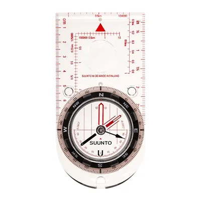
Suunto M-3 G
A baseplate compass with adjustable declination, useful where it tops 14°: set the offset once and skip the math on every bearing. Globally balanced needle, magnifier, 1.69 oz.
View on Amazon (opens in a new tab)
Worth watching
REI walks through the parts of a compass, setting declination and taking a bearing from a map and in the field, the three steps this guide covers.
The video is hosted by YouTube (Google): nothing loads until you play it, and Google may then set cookies.
FAQ
How do you take a bearing with a map and compass?
Lay the compass on the map with one edge of the baseplate running from where you are to where you’re going, direction-of-travel arrow toward your destination. Turn the dial until its lines run parallel to the map’s north-south lines. Lift the compass, turn until the red needle sits in the orienting arrow, then follow the direction-of-travel arrow to a distant landmark.
Do I really need to adjust for declination?
In much of the US, yes. On October 23, 2026, the WMM2025 model gives 14.6° east at Mount Rainier and 15.3° west at Mount Katahdin, enough to put you more than 1,000 feet off line after a mile. Subtract an east declination from a map bearing before following it, add a west one, and check the current value with NOAA’s calculator.
Why is my compass pointing the wrong way?
Usually because something magnetic or metal is too close and deflects the needle: a phone, the magnet in a phone case or jacket, a belt buckle. Keep them away while taking a bearing and hold the compass flat. More rarely, magnetic rocks throw the reading off, as in the Cuillin mountains on Scotland’s Isle of Skye, according to Ordnance Survey.
What’s the difference between true north, map north, and magnetic north?
True north is the direction of the North Pole, the north of the meridians. Map or grid north is the north of the map’s grid lines or edge, which follows the map projection. Magnetic north is where the needle points, and it shifts slowly every year. The angle between true and magnetic north is called declination.
Is my phone’s compass good enough for hiking?
Phones and mapping apps are very useful, but they depend on battery life and sometimes on cell service, as Ordnance Survey points out. A baseplate compass works anywhere, needs no power, and helps you hold a direction in poor visibility. Carrying both, and knowing how to use the compass, is still the safest bet.
Sources
- Ordnance Survey, A Beginner’s Guide to Using a Compass, OS GetOutside, May 14, 2026, accessed October 23, 2026. osmaps.com https://osmaps.com/discover/guides/a-beginners-guide-to-using-a-compass/ ↩
- Ordnance Survey, A tale of three norths, OS GetOutside, March 27, 2019, accessed October 23, 2026. osmaps.com https://osmaps.com/discover/guides/a-tale-of-three-norths/ ↩
- IGN, S’orienter très précisément avec une boussole et une carte IGN, tutorial, accessed October 23, 2026. ign.fr https://www.ign.fr/publications-de-l-ign/institut/Ressources_pedagogiques/orientation/tuto_boussole_precision.pdf ↩
- NOAA, National Centers for Environmental Information, World Magnetic Model (WMM), accessed October 23, 2026. ncei.noaa.gov https://www.ncei.noaa.gov/products/world-magnetic-model ↩
- British Geological Survey, World Magnetic Model Calculator, WMM2025 model, values calculated by the editorial team for October 23, 2026. geomag.bgs.ac.uk https://geomag.bgs.ac.uk/data_service/models_compass/wmm_calc.html ↩

Camping, backpacking, bushcraft and hiking
Guillaume Hoarau writes for Outfarer about camping, backpacking, bushcraft, and hiking. A survival-skills buff and a collector of vintage field manuals, he loves clear explanations, lists that actually help and other people’s stories, which he tells well.


 Julien de Jurquet