 Français (France)
 English (UK)
 English (US)
 Deutsch (Deutschland)

Contents
A junction in the woods, three trails heading off under the beeches, and on one trunk, at eye level, a small yellow stripe. It doesn’t tell you where you’re going or how far: it only tells you you’re still on your route. That’s the whole art of trail marking, and also its limit.
France’s hiking federation sums it up in its official charter: trail markers are there to guide, direct, and reassure hikers all along the way [1]. In France, its rules apply to more than 110,000 miles (180,000 km) of trails [1]. But cross a border and the same colors stop meaning the same thing: two white and red bars mean a GR long-distance trail in France, three white-red-white bands a mountain trail in Switzerland.
In France: the color tells you the type of route
The federation’s charter, in its 2019 edition, sets three codes for hiking routes [1]. White over red, two stacked rectangles, marks a grande randonnée, a long-distance trail approved by France’s hiking federation, such as the GR20 in Corsica or the Tour du Mont Blanc. Yellow over red marks a GR® de Pays, a regional route that’s also approved. Yellow alone marks a PR, a local hiking route. GRs and GRs de Pays are marked in both directions; a PR may be marked in one direction only, though the charter prefers both [1].
Two signals round out the code. Before a turn, the regular marker gets an arrow: white on a GR, yellow on a GR de Pays or a PR [1]. In front of a wrong turn, a a diagonal X, meaning don’t take this trail repeats the route’s colors: white on red for a GR, yellow on red for a GR de Pays, yellow for a PR [1]. Where two routes share a section, only the GR marking stays alongside a GR de Pays, but a PR’s marking continues the whole way [1].
| Marker | Route | Good to know |
|---|---|---|
| Two circles joined to a triangle | Mountain biking | Yellow for local loops, red for long crossings of more than 50 miles (80 km); a loop’s difficulty shows in green, blue, red, or black |
| Orange rectangle | Horseback riding | Two orange rectangles above two orange circles for carriage-driving routes |
| Yellow markers, closely spaced | Snowshoeing, beginner loop | A loop of 0.6 to 1.6 miles (1 to 2.5 km) starting from a ski resort or village; to get started, see snowshoeing for beginners |
Source: Charte officielle du balisage et de la signalisation, FFRandonnée, 2019 edition.
In Switzerland: the color tells you how tough it is
Switzerland made a different choice: its colors sort trails by what they ask of the hiker. The federal law on footpaths and hiking trails sets three categories, signed to a national standard, SN 640 829a [2]. A hiking trail is signed in yellow and makes no special demands [3]. A mountain hiking trail keeps yellow signposts, but with white-red-white tips, and its markers are white-red-white: often steep, narrow, and partly exposed, it calls for sure footing, good fitness, and no fear of heights [3]. An alpine hiking route has blue signposts with white-blue-white tips and white-blue-white markers [3].
Swiss signposts usually give a hiking time rather than a distance. It’s based on an average pace of 4.2 km/h (2.6 mph) on flat ground, without breaks, adjusted by a Suisse Rando formula for climbs, descents, and grade; it’s rounded to the nearest five minutes, and to the hour for times over three hours that fall within five minutes of it [3]. It’s a no-breaks time for an average hiker: yours may differ, and our guide to estimating hiking time explains how to adjust it.
In the Austrian and German Alps: the difficulty is on the signpost
In the Austrian and Bavarian Alps, the marker changes little from one trail to the next. According to the German Alpine Club, the intermediate markers painted on trees and rocks are usually red-white-red, whatever the trail’s difficulty [4]. The difficulty shows up on the yellow signposts instead: a blue dot for an easy trail, a red dot for a moderately difficult one, and a black dot for a difficult one, like ski runs in Europe [4]. At the bottom of the signpost is the name of whoever maintains the trail, often a section of the Alpine Club [4]. The same page also mentions white-red-white markers: remember the red and white bands rather than their order. To compare these colors with other scales, our guide to mountain hiking grades lays them side by side.
In England and Wales: the color tells you who may use the path
In England and Wales, the logic changes again: the colored arrow shows neither difficulty nor the type of hike, but the path’s legal status as a a route across private land that the public has a legal right to use [5]. The British government spells out who may use each category [6], as the table below sums up. So a red arrow is no promise of a road you can drive: Natural England points out that it shows a status, not the condition of the route [5]. On a National Trail or a marked loop, the arrow comes with the route’s own symbol [5].
| Arrow | Category | Who may use it |
|---|---|---|
| Yellow | Footpath | On foot |
| Blue | Bridleway | On foot, on horseback, and by bike |
| Purple | Restricted byway | Anything without a motor |
| Red | Byway open to all traffic | Any vehicle, cars included |
Sources: Natural England, booklet NE68 (colors); GOV.UK (users). Mobility scooters and power wheelchairs may use all these categories.
In the US: paint blazes
Back home, the marker is a blaze: a rectangle of paint on a trunk or a rock. The best known belongs to the Appalachian Trail, a white rectangle 2 by 6 inches that has marked the trail since the 1930s [7]. Two blazes stacked 2 inches apart warn of an abrupt turn or a spot where you need to stay alert; the organization that manages the trail asks clubs to use them sparingly, or they stop meaning anything [7]. Colors then vary from park to park: in Shenandoah National Park, white marks the Appalachian Trail, blue a regular hiking trail, and yellow a horse trail [8]. Check the park map before you head out.
Elsewhere: what to look for in seven more destinations
Every country has its own logic. In Canada and Australia, the thing to check is the rating parks give each trail: it also tells you how many markers to expect.
| Country | What you’ll see | What it means |
|---|---|---|
| Italy | White-and-red markers; at junctions, a numbered red-white-red flag | You’re on the right trail, nothing more; its rating, from T to EEA (via ferrata), is in the trail description [9] |
| Spain | A white stripe over a red, yellow, or green one | The color gives the length: GR over 31 miles (50 km), PR 6.2 to 31 miles (10 to 50 km), SL under 6.2 miles (10 km) [10] |
| Greece | Yellow diamond on the E4, red on national long-distance trails | A code set by the government in 2017; trails marked earlier keep their old markers [11] |
| Norway | Cairns, some painted with a red T; in forests, blue or red | The T means a route maintained by the DNT, Norway’s trekking association. In large forest areas, blue marks summer trails and red ski routes, which can cross marshes [12] |
| Canada | In national parks, a rating from “easy” to “route” | Few markers on a difficult trail; a “route” is just a suggested line, not maintained [13] |
| Australia | A grade from 1 to 5 on signs, in the state of Victoria for example | At grade 5, expect an unmarked track: you’ll need to navigate [14] |
| New Zealand | Orange triangles on trees, poles above the tree line | A marker in another color flags conservation work, not a trail [15] |
Official sources accessed October 23, 2026.
When the markers run out
The French charter says it up front: trail markers go hand in hand with maps, guidebooks, and route cards [1]. A marker hides behind a branch, fades under moss, or disappears with a downed tree. If you haven’t seen one in a while, I can only see one sensible move: head back to the last marker you were sure of rather than guess your way forward, then check the map again. A compass does the rest, and our guide to navigating with a map and compass shows how. To figure out what the detour will cost you, estimate your hiking time.
Gear related to this article
No affiliation: no commission, no sponsored products.
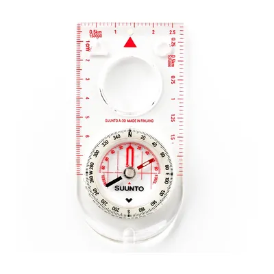
Suunto A-30 NH
A 1.1 oz baseplate compass with a magnifier and luminous markings, sold with metric or USGS map scales: for going back to the map when the blazes run out.
View on Amazon (opens in a new tab)
FAQ
What do white and red trail markers mean in Europe?
In France, two stacked rectangles, white above and red below, mark a GR®, a long-distance trail approved by France’s hiking federation and marked in both directions. In Switzerland, three white-red-white bands mean something else: a mountain hiking trail, often steep and partly exposed, which calls for sure footing and no fear of heights.
What does an X painted on a tree mean in France?
On a marked trail in France, a diagonal cross, called a St. Andrew’s cross, marks a wrong turn: don’t take that trail. It repeats the route’s colors: white on red for a GR, yellow on red for a GR de Pays, and yellow for a PR, according to the official charter of France’s hiking federation.
What’s the difference between a GR, a GR de Pays, and a PR?
The GR, marked in white and red, and the GR de Pays, marked in yellow and red, are routes approved by France’s hiking federation and marked in both directions. The PR, a local hiking route marked in yellow, may be marked in one direction only. All three codes appear in the federation’s official trail-marking charter, 2019 edition.
What does white-blue-white mean in Switzerland?
It marks an alpine hiking route, the most demanding category of the Swiss network, with blue signposts. According to the official signage manual, these routes may cross snowfields, glaciers, scree, and short scrambling sections, with no guarantee of fixed aids, and call for an altimeter, a compass, and a rope and ice ax on glaciers.
What do the yellow and blue arrows mean on trails in England?
In England and Wales, a yellow arrow marks a footpath, a public right of way on foot; a blue arrow marks a bridleway, open to horseback riders and cyclists too. Purple and red mark routes where other kinds of transport have a right to pass. The color shows the path’s legal status, not its difficulty or condition.
Sources
- Fédération française de randonnée pédestre, Charte officielle du balisage et de la signalisation, 2019 edition, accessed October 23, 2026. ffrandonnee.fr https://www.ffrandonnee.fr/Media/Default/Documents/federation/espace-professionnels/Charte%20officielle_balisage_signaletique_ffrandonnee_Edition%202019_d.pdf ↩
- Suisse Rando and Swiss Alpine Club, Itinéraires en montagne en dehors du réseau officiel des chemins de randonnée : recommandation en matière de signalisation, September 3, 2021, accessed October 23, 2026. swisshiking.ch https://www.swisshiking.ch/fr/media/download/8fe933b8364a386cf930fe9c19b3c72c2e5f5d99 ↩
- Swiss Federal Roads Office and Suisse Rando, Signalisation des chemins de randonnée pédestre, manual, slow traffic guidance no. 6, 2013, accessed October 23, 2026. swisshiking.ch https://swisshiking.ch/fr/media/download/d2b3e6921c5476fccc67b4c0f66771f169539373 ↩
- Deutscher Alpenverein, Schwierigkeitsgrade von Bergwegen, July 2, 2025, accessed October 23, 2026. alpenverein.de https://www.alpenverein.de/artikel/schwierigkeitsgrade-von-bergwegen_8de95a6d-b490-4963-86cf-a0907c48a331 ↩
- Natural England, Waymarking public rights of way, booklet NE68, 2008, accessed October 23, 2026. assets.publishing.service.gov.uk https://assets.publishing.service.gov.uk/government/uploads/system/uploads/attachment_data/file/414626/waymarking-rights-of-way.pdf ↩
- GOV.UK, Rights of way and accessing land: use public rights of way, accessed October 23, 2026. gov.uk https://www.gov.uk/right-of-way-open-access-land/use-public-rights-of-way ↩
- Appalachian Trail Conservancy, Trail Design, Construction and Maintenance, trail management policy, accessed October 23, 2026. appalachiantrail.org https://appalachiantrail.org/wp-content/uploads/2022/07/Trail-Design-Construction-and-Maintenance.pdf ↩
- National Park Service, Stony Man: The Appalachian Trail, Shenandoah National Park, accessed October 23, 2026. nps.gov https://www.nps.gov/places/000/stony-man-the-appalachian-trail.htm ↩
- Club Alpino Italiano, Sentieri. Pianificazione, segnaletica e manutenzione, Quaderno di escursionismo no. 1, 4th edition, 2010, accessed October 23, 2026. cai.it https://www.cai.it/wp-content/uploads/2024/04/8-1-Quaderno_1_2010.pdf ↩
- Federación Española de Deportes de Montaña y Escalada, Manual de señalización de senderos GR®, PR® y SL®, 2021 digital edition, accessed October 23, 2026. fedme.es https://fedme.es/wp-content/uploads/2024/07/2024_ManualSenderosFEDME_21.pdf ↩
- Greek Ministry of Environment and Energy, decision 151344/165, Καθορισμός τεχνικών προδιαγραφών χάραξης, σήμανσης, διάνοιξης και συντήρησης των ορειβατικών πεζοπορικών μονοπατιών, ΦΕΚ Β 206, January 30, 2017, article 10, original text as reproduced by e-nomothesia.gr, accessed October 23, 2026. e-nomothesia.gr https://www.e-nomothesia.gr/kat-periballon/upourgike-apophase-151344-165-2017.html ↩
- Den Norske Turistforening, DNT’s marked trails and routes, accessed October 23, 2026. dnt.no https://www.dnt.no/en/Trips/Tips-and-tricks/articles/Routes/ ↩
- Parks Canada, Guide to trail ratings and descriptions, accessed October 23, 2026. parks.canada.ca https://parks.canada.ca/voyage-travel/experiences/sports/randonnee-hiking/niveaux-sentiers-trail-ratings ↩
- Parks Victoria, How walking tracks are rated, Victoria, Australia, accessed October 23, 2026. parks.vic.gov.au https://www.parks.vic.gov.au/things-to-do/hiking-and-bushwalking/choose-the-right-hike/how-walking-tracks-are-rated ↩
- Department of Conservation, Walking track categories, New Zealand, accessed October 23, 2026. doc.govt.nz https://www.doc.govt.nz/parks-and-recreation/things-to-do/walking-and-tramping/track-categories/ ↩

Camping, backpacking, bushcraft and hiking
Guillaume Hoarau writes for Outfarer about camping, backpacking, bushcraft, and hiking. A survival-skills buff and a collector of vintage field manuals, he loves clear explanations, lists that actually help and other people’s stories, which he tells well.


