 Français (France)
 English (UK)
 English (US)
 Deutsch (Deutschland)

Contents
What changed on 1 January 2026
€4.50. That is now the price of a half-hour slot to set foot on one of Madeira’s official trails. Since 1 January 2026, access to the autonomous region’s classified trails has followed new rules: €4.50 for the general public, €3 for visitors accompanied by a tour company bound by an agreement, known as a protocol, to the Institute of Forests and Nature Conservation (IFCN), and compulsory booking on the SIMplifica portal [1].
Working with the University of Madeira, the IFCN has set the carrying capacity of every classified trail, in other words how many people it can take. That capacity is now divided into 30-minute slots, from sunrise to sunset, to spread visitors across the day. Above all, every visitor must now register in advance, whatever their age or status [2]. Residents of the region pay nothing, but they too have to book [2] [3].
And the checks are anything but theoretical. Entering a classified trail without a booking is an infraction: you may be asked to leave the trail to put things right, and the regulations provide for a fine [3].
Booking your slot on SIMplifica
Booking is online only, on SIMplifica, the Regional Government of Madeira’s digital services portal [3]. There you choose your trail, your day and your entry time from the half-hour slots still available, and the general public pays at the time of booking [1] [2]. The tourism board, Visit Madeira, publishes a step-by-step tutorial, and each trail’s page states its fee [1].
Before paying, read the rescheduling terms. The IFCN only refunds or reschedules access when restrictions affect the site, by its own decision; in bad weather, it may handle booking transfers itself [2]. A walk cancelled because you have changed your mind is therefore not refunded.
Seven official walks to start with
| Trail | Distance | Difficulty | Duration | Fee for a visitor over 12 |
|---|---|---|---|---|
| PR 11, Vereda dos Balcões | 1.5 km (3 km there and back) | Easy | 1 h 30 min | €4.50 |
| PR 6.1, Levada do Risco | 1.5 km (3 km there and back) | Easy | 2 h | €4.50 |
| PR 8, Vereda da Ponta de São Lourenço | 4 km (plus 4 km back) | Moderate | 2 h 30 min | €4.50 |
| PR 1.2, Vereda do Pico Ruivo | 2.8 km (5.6 km there and back) | Moderate | 1 h 30 min | €4.50 |
| PR 6, Levada das 25 Fontes | 4.3 km (8.6 km there and back) | Moderate | 3 h | €4.50 |
| PR 1, Vereda do Areeiro | 6.1 km, one way | Moderate | 3 h | €4.50 to the Pedra Rija viewpoint and back; €10.50 through to Pico Ruivo |
| PR 9, Levada do Caldeirão Verde | 8.7 km (17.4 km there and back) | Moderate | 6 h 30 min | €4.50 |
Distances, difficulty ratings, durations and fees as published by Visit Madeira on each trail’s page, accessed 22 October 2026. The duration shown is the one given on the page.
For a first outing, the Vereda dos Balcões is the gentlest: 1.5 km from regional road ER 103 at Ribeiro Frio, along a levada, to the Balcões viewpoint; on a clear day, the view reaches the island’s central massif, with Pico do Areeiro, Pico das Torres and Pico Ruivo [5].
The Levada das 25 Fontes, the ‘levada of the 25 springs’, sets off from Rabaçal, on regional road ER 105, between 964 and 1,288 m above sea level: 4.3 km out, about 3 hours, through surroundings that the official page promises will be exuberant [6]. The Vereda da Ponta de São Lourenço is a change of scene: 4 km along a peninsula, from Baía d’Abra to Casa do Sardinha, between 23 and 126 m above sea level [7].
From the same starting point at Rabaçal, the Levada do Risco, rated easy, shares the first stretch of the 25 Fontes trail before branching off: 1.5 km out, about 2 hours there and back, at around 1,000 m [8]. To reach the roof of the island without the big crossing, take the Vereda do Pico Ruivo from Achada do Teixeira, home to a rock formation called Homem em Pé, the ‘Standing Man’: in 2.8 km, it reaches Pico Ruivo, at 1,862 m the highest point in the archipelago [9]. To adapt these times to your own pace, see our method for estimating walking time.
The other two ask more of you. The Levada do Caldeirão Verde runs for 8.7 km from Queimadas Forest Park to Caldeirão do Inferno, passing the Caldeirão Verde lake, formed by the water of a stream that falls vertically into it: the page says to allow 6 h 30 min [10]. The Vereda do Areeiro links the Pico do Areeiro viewpoint to Pico Ruivo in 6.1 km and about 3 hours, at the heart of a massif that belongs to the Natura 2000 network [4].
Weather, closures and caution
Rain, strong wind or fog can close a trail temporarily for safety reasons; Visit Madeira considers it essential to check the weather forecast before setting off [3]. The status of each classified trail, open, partly restricted or inaccessible, can be checked on the map on Visit Madeira’s website and through the IFCN’s channels [3] [1].
Getting to the start and parking
From Funchal, you reach the start of each trail by hire car, by taxi or on an organised excursion; each official page gives the start and finish points, worth checking before you choose your slot. Think about getting back: several trails, such as the Vereda do Areeiro, are one way.
Parking on the island follows a colour code: white lines are free, though some are reserved for residents; blue lines are paid; yellow lines mean no parking. Charges generally apply from Monday to Friday, 8am to 8pm, and on Saturdays, 8am to 2pm; Sundays and public holidays are free. You pay at the ticket machine or through the iPark Driver app. Expressways and main roads are toll-free [3].
Once your slot is booked, all that remains is to get up early, follow the murmur of water along its stone channel, and let the laurel forest do the rest.
Gallery: Madeira’s trails in five landscapes
Five real photos taken on the official trails listed above or where they start, published under free licences on Wikimedia Commons by their authors, who are credited under each image. Tap or click a photo to enlarge it.
Kit related to this article
No affiliation: no commission, no sponsored products.
 Bergverlag Rother
Rother Walking Guide: Madeira
70 levada and mountain walks with height profiles and 1:50,000 maps; the 2025 edition predates the 2026 booking rules, so check SIMplifica first.
View on Amazon (opens in a new tab)
Worth watching
The official walkthrough from Madeira’s regional innovation agency, which runs SIMplifica: buying a classified-trail ticket online, with no portal account needed for tourists and non-residents.
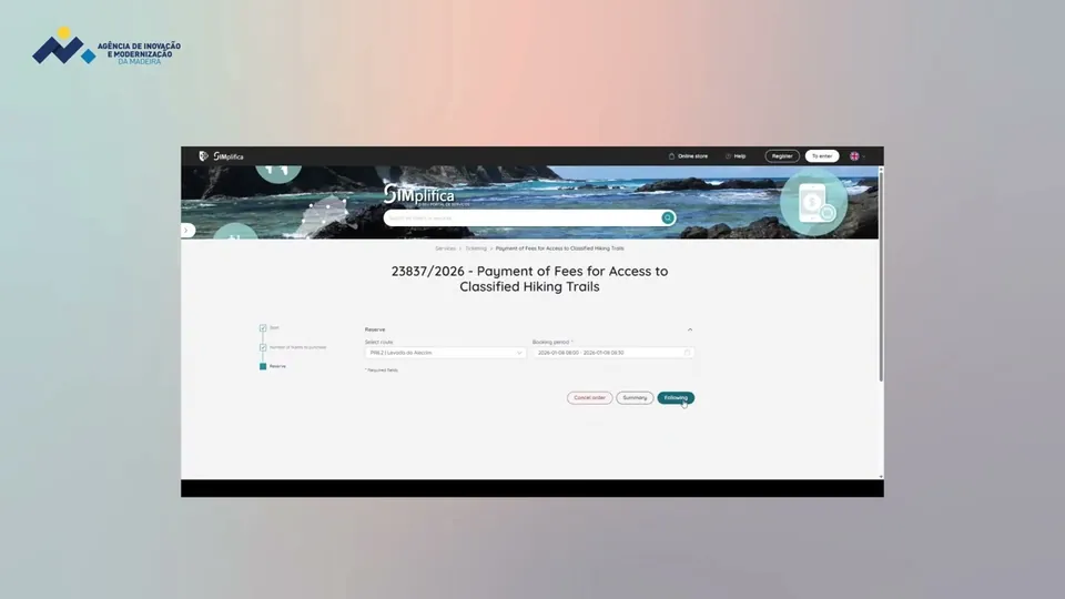
The video is hosted by YouTube (Google): nothing loads until you play it, and Google may then set cookies.
FAQs
Do you need to book to walk Madeira’s levadas?
Yes, for every classified trail (PR) on the island since 1 January 2026. Booking is online only, on SIMplifica, the regional government’s portal, by 30-minute entry slot, from sunrise to sunset. Every visitor must be registered, whatever their age. Entering without a booking is an infraction that can lead to a fine.
How much does it cost to walk Madeira’s trails in 2026?
€4.50 per person for the general public, paid when you book. The crossing from Pico do Areeiro to Pico Ruivo (PR 1) costs €10.50. With a tour company that has a protocol with the IFCN, access comes to €3. Children aged 12 and under pay nothing, and Madeira residents walk free of charge, once they have booked.
What happens if a trail closes because of the weather?
Rain, strong wind or fog can close a trail temporarily. The IFCN only reschedules or refunds access when restrictions affect the site by its own decision, and it may then transfer bookings itself. Check the trail’s status on Visit Madeira’s map before you set off, and never set foot on a closed trail.
Which levada is best for a first walk on Madeira?
The Vereda dos Balcões (PR 11) is the easiest of the trails listed here: 1.5 km from Ribeiro Frio, so 3 km there and back, about 1 h 30 min, to a viewpoint that looks out over the peaks in the centre of the island on a clear day. The Levada das 25 Fontes (PR 6) is longer, 8.6 km there and back, and rated moderate.
Sources
- Visit Madeira, Hiking, official page of the Madeira tourism board, accessed 22 October 2026. visitmadeira.com https://www.visitmadeira.com/en/what-to-do/nature-seekers/activities/hiking/ ↩
- IFCN (Instituto das Florestas e Conservação da Natureza, Madeira’s Institute of Forests and Nature Conservation), New rates and pricing model for 2026, information for economic operators, accessed 22 October 2026. ifcn.madeira.gov.pt https://ifcn.madeira.gov.pt/images/Destaques/Informacao/Info_OperEcon/Inf_OE_GAB_ING.pdf ↩
- Visit Madeira, Frequently Asked Questions, accessed 22 October 2026. visitmadeira.com https://visitmadeira.com/en/travel-info/faq/ ↩
- Visit Madeira, PR 1 - Vereda do Areeiro, trail page, accessed 22 October 2026. visitmadeira.com https://www.visitmadeira.com/en/what-to-do/nature-seekers/activities/hiking/pr-1-vereda-do-areeiro/ ↩
- Visit Madeira, PR 11 - Vereda dos Balcões, trail page, accessed 22 October 2026. visitmadeira.com https://www.visitmadeira.com/en/what-to-do/nature-seekers/activities/hiking/pr-11-vereda-dos-balcoes/ ↩
- Visit Madeira, PR 6 - Levada das 25 Fontes, trail page, accessed 22 October 2026. visitmadeira.com https://www.visitmadeira.com/en/what-to-do/nature-seekers/activities/hiking/pr-6-levada-das-25-fontes/ ↩
- Visit Madeira, PR 8 - Vereda da Ponta de São Lourenço, trail page, accessed 22 October 2026. visitmadeira.com https://www.visitmadeira.com/en/what-to-do/nature-seekers/activities/hiking/pr-8-vereda-da-ponta-de-sao-lourenco/ ↩
- Visit Madeira, PR 6.1 - Levada do Risco, trail page, accessed 22 October 2026. visitmadeira.com https://www.visitmadeira.com/en/what-to-do/nature-seekers/activities/hiking/pr-61-levada-do-risco/ ↩
- Visit Madeira, PR 1.2 - Vereda do Pico Ruivo, trail page, accessed 22 October 2026. visitmadeira.com https://www.visitmadeira.com/en/what-to-do/nature-seekers/activities/hiking/pr-12-vereda-do-pico-ruivo/ ↩
- Visit Madeira, PR 9 - Levada do Caldeirão Verde, trail page, accessed 22 October 2026. visitmadeira.com https://www.visitmadeira.com/en/what-to-do/nature-seekers/activities/hiking/pr-9-levada-do-caldeirao-verde/ ↩
- Service-public.fr (official French government information site), Quels sont les numéros en cas d’urgence (Samu, pompiers...) et les numéros d’écoute ?, page in French, checked by Service-public.fr on 25 August 2026, accessed 22 October 2026. service-public.gouv.fr https://www.service-public.gouv.fr/particuliers/vosdroits/F33954 ↩
- IFCN (Instituto das Florestas e Conservação da Natureza), FAQ: New Model of Rates and Reservations for the IFCN’s Classified Walking Routes, updated 2 June 2026, accessed 22 October 2026. ifcn.madeira.gov.pt https://ifcn.madeira.gov.pt/pt/atividades-de-natureza/percursos-pedestres-recomendados/faq-s-taxas-percursos-pedestres-classificados/frequently-asked-questions-fees-classified-walking-routes.html ↩

Trail running, snow, water, nature and destinations
Nolwenn covers trail running, snow, water, nature and destinations for Outfarer. Curious about everything, from meteor showers to night-train timetables, she has a knack for unearthing the one detail that changes everything, and putting it in a single sentence.

 Guillaume Hoarau


 Arnaud Couderc