 Français (France)
 English (UK)
 English (US)
 Deutsch (Deutschland)

Contents
What to expect on La Gomera
A forest that works only half as well without the mist: Garajonay National Park covers 3,984 ha [1], and about 70% of it is laurel forest, a relic of woodland that once covered much of southern Europe. UNESCO added the park to its World Heritage list in 1986. [2] On the south side of the park, where the mist is rarer, a different and drier woodland grows. [4]
Good news for anyone who likes variety: that is only one half of the island. The other half is steep, sunny and deeply creased, with ravines, terraced fields, palm groves and stretches of coast that the GR 132 covers piece by piece. [3] Anyone planning to explore La Gomera on foot therefore has two very different landscapes to choose from.
Garajonay: three ways up the Alto de Garajonay
The summit stands at 1,487 m and is counted among the finest viewpoints in the Canary Islands. [4] In clear weather, up to five islands can be seen from the top. [5] The island’s tourism website (lagomera.travel) describes three approaches, which differ markedly in effort and character.
The shortest is the route from Contadero: out and back along the same path, through young Fayal-Brezal that has replaced old pine plantations here. The page gives 2.5 km and 1 h 30 min. [6] It gets longer from the La Laguna Grande recreation area, where an old mule track, paved in places, climbs through forest and leads back down at the end: 10.2 km and 6 h 15 min. [4] The third option is the circuit from Chipude over the Alto, the Laguna Grande and the pottery village of El Cercado, listed at 4 h 10 min. [5]
| Walk | Length | Time | Type |
|---|---|---|---|
| Contadero - Alto - Contadero | 2.5 km | 1 h 30 min | out and back |
| Chipude - Alto - Laguna Grande - El Cercado | not stated | 4 h 10 min | circuit |
| Laguna Grande - Alto - Laguna Grande | 10.2 km | 6 h 15 min | circuit |
| San Sebastián - Hermigua (GR 132 via Enchereda) | 26.3 km | 8 h 45 min | one way |
| GR 132 Costas de La Gomera | 127 km (Forwalk: 114 km) | 49 h (Forwalk: 5 days) | circuit |
Turismo de La Gomera and Forwalk, accessed 7 November 2026. The times are estimates given by the websites, not measured walking times; lengths given without a unit are read as kilometres.
Two things stand out in the comparison. First, some of the websites’ lengths carry no unit (we read them as kilometres), and the Chipude circuit gives none at all. Second, the times do not add up: the 10.2 km circuit is listed at 6 h 15 min, well above the 4 h 10 min for the Chipude circuit, although both reach the Alto. So plan by your own pace, and use the figure that the rule of thumb for walking times gives you, not a single number from a web page.
GR 132: once round the island, but how far exactly?
The GR 132 is called Costas de La Gomera, starts and ends in San Sebastián, and follows the coastal band round the island. The tourism website gives 127 km and 49 h of walking time, a circuit that climbs and descends without a break. [3] The Forwalk platform for the island’s paths gives 114 km, doable in 5 days, and rates it an expert walk requiring very good fitness; in its description text it speaks of about 120 km. [7]
From 127 km and 49 h comes only a calculation, not an official stage: spread over eight days, that would be a good six hours of walking a day, without breaks. Anyone with less time walks individual sections. One example from the tourism website is the route from San Sebastián to Hermigua on the GR 132 via Enchereda: 26.3 km, 8 h 45 min, a long crossing of the island on little-used paths, intended for experienced walkers only. [8]
GR 131: the path along the ridge
Anyone who prefers to stay high takes the GR 131, Cumbres de La Gomera. It crosses the island along its central ridge, passing through the Alto de Garajonay and by the volcanic plugs of Fortaleza de Chipude, Roque Agando and Roque Cano. The description calls it one of the most complete and demanding long-distance walks on the island, with constant ups and downs. [9]
Getting there: ferry from Tenerife, bus on the island
From Tenerife, Fred. Olsen sails from Los Cristianos to San Sebastián in 50 minutes, with up to four departures a day. [10] From San Sebastián, the company also runs coastal services to Valle Gran Rey and to Playa de Santiago. [11]
| Route | Duration | Distance |
|---|---|---|
| San Sebastián - Los Cristianos (Tenerife) | 50 min | 39 km |
| San Sebastián - Valle Gran Rey (1 stop) | 70 min | 31.5 km |
| San Sebastián - Playa de Santiago | 30 min | 12.5 km |
Fred. Olsen Express, San Sebastián de La Gomera terminal page, accessed 7 November 2026; timetables and prices change, so always check the company’s current table.
On the island, GuaguaGomera is the public bus service. In August 2026 it announced new connections for the last quarter of the year, including early departures from 7am from San Sebastián to Valle Gran Rey and to Vallehermoso, also at weekends and on public holidays. [12] Check the final timetables with GuaguaGomera itself before you plan. And if you are on Tenerife beforehand and want to climb Teide: a separate reservation requirement applies there, and here is how the permit works.
Rules in the park: no tent, no fire, no bikes on the path
Overnight stays are expressly not allowed in the national park, for reasons of nature conservation and safety. The island offers a wide choice of accommodation for the purpose, the park authority writes. [13] Anyone walking the GR 132 or GR 131 in stages therefore plans each night in a village. According to the environment ministry, there is still only a single camping option in the area, a private site in the hamlet of El Cedro. [14] Whether it is still operating is best checked directly before you rely on it.
The park’s other rules are set out in the overview; they go back to the use and management plan. [13]
| Subject | Rule |
|---|---|
| Overnight stays | not allowed |
| Fires | only at the fire pits at Laguna Grande, during set periods |
| Bicycles | on roads and most tracks, not on walking paths |
| Dogs | on the paths, but on a lead |
| Bathing | forbidden in the forest’s streams |
| Climbing | only with permission from the park management |
| Drones, paragliders, fireworks | to be avoided |
| Litter | take it away with you |
Gobierno de Canarias, Garajonay National Park, Normas de visita, accessed 7 November 2026.
When to walk: wet winter, dry summer
The environment ministry gives March to June as the best time for plant lovers, because flowering and growth then reach their peak. The wettest period runs from November to February, but the spells of rain are rarely long, and the island looks green right down to the coast. July to September is the driest and hottest period, while the north stays pleasantly cool. [14] If you are planning now, in November, pack a waterproof jacket and waterproof boots, and stay flexible.
Fires and closures: the part the guidebooks skip
On 4 August 2012, the most ecologically damaging wildfire in the Canary Islands for decades broke out on La Gomera. It covered more than 3,613 ha of the island, nearly 20% of the national park’s area, over 740 ha, and burnt the largest area of laurel forest ever to go up in flames in the Canaries. [15] The park director later spoke of an exceptional fire in an exceptional place, which had started in the worst-preserved areas and then entered ancient forest. [16] The park authority also mentions the 1984 fire at Los Roques, in which 20 people died. [13]
Today the island protects itself with warning levels. In August 2025, the Cabildo de La Gomera lowered its precautions to level 2, which reopened the path network, and forest and recreation areas were accessible again. Level 2 does, however, still ban open fires outdoors, including gas and wood stoves. [17] The park authority also reserves the right to close paths, viewpoints and tracks because of safety, weather warnings, fire risk or works. [13] The environment ministry calls wildfire the greatest risk to the park. [18]
Before you set off: information, visitor centres and kit list
The Juego de Bolas visitor centre in Agulo is open daily from 9.30am to 4.30pm, closed on 25 December and 1 January, telephone 922 477 222. The information centre at Laguna Grande, on the GM-2 at kilometre 26.5, is open daily from 8.30am to 4.30pm. [19] On the park notices page, two restrictions were listed when we checked on 7 November 2026: temporary closures of the CV-14 road near El Rejo, each from 7am to 1pm for slope stabilisation, and a track closed to vehicles at the Meseta de Vallehermoso, which can still be passed on foot. [20]
In the end, only one question remains, and it is a pleasant one: do you want the mist first, or the coast?
Kit related to this article
No affiliation: no commission, no sponsored products.
 Bergverlag Rother
Rother Walking Guide: La Gomera
73 coastal and mountain walks with GPS tracks to download, including routes in Garajonay National Park; 7th edition 2025.
View on Amazon (opens in a new tab)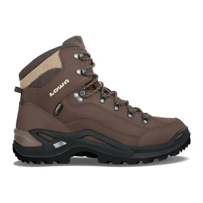
Lowa Renegade GTX Mid
A versatile mid-cut walking boot: leather upper, Gore-Tex membrane and Vibram sole, on a last made for medium-width feet. Men’s model, also made in a women’s version.
View on Amazon (opens in a new tab)
FAQs
Can I camp in Garajonay National Park?
No. According to the park authority, overnight stays are not allowed in the park, for reasons of nature conservation and safety. The environment ministry mentions only one private campsite, in the hamlet of El Cedro. Anyone on the GR 132 or GR 131 plans each night in a village with accommodation, and asks there directly if in doubt.
How long does the GR 132 round the island take?
That depends on the source. The island’s tourism website gives 127 km and 49 h of pure walking time, the Forwalk platform 114 km in 5 days. Spread over eight days, 49 h works out at a good six hours a day, but that is only a calculation, not an official stage. The walk is rated as demanding.
How do I get from Tenerife to La Gomera?
By ferry from Los Cristianos to San Sebastián de La Gomera. Fred. Olsen Express gives a crossing time of 50 minutes and up to four departures a day. Timetables change with the day of the week and the season, so look at the company’s current table before you plan, especially for the evening return.
When is the best time to walk on La Gomera?
The environment ministry gives March to June for plant lovers. From November to February it rains most, but rarely for long, and the island is green. July to September is the driest and hottest, pleasantly cool in the north. In high summer, the Cabildo can close the path network for a time when there is a fire risk.
What happens when the Cabildo closes the paths?
When the wildfire risk is high, the Cabildo activates precaution levels. In August 2025 the path network was closed for a time and reopened under level 2, with a continuing ban on open fires outdoors, gas stoves included. The park can also close paths because of weather warnings. Check for closures before every walk, and pick another walk if in doubt.
Sources
- Ministerio para la Transición Ecológica, Garajonay: Ficha técnica (in Spanish), accessed 7 November 2026. miteco.gob.es https://www.miteco.gob.es/va/parques-nacionales-oapn/red-parques-nacionales/parques-nacionales/garajonay/ficha-tecnica.html ↩
- UNESCO World Heritage Centre, Garajonay National Park, Spain (news item of 29 April 2008, in English), accessed 7 November 2026. whc.unesco.org https://whc.unesco.org/en/news/430 ↩
- Turismo de La Gomera, GR 132 Costas de La Gomera (in English), accessed 7 November 2026. lagomera.travel https://lagomera.travel/en/hiking/la-gomera/gr-132-costas-de-la-gomera/ ↩
- Turismo de La Gomera, Laguna Grande - Alto Garajonay - Laguna Grande (in English), accessed 7 November 2026. lagomera.travel https://lagomera.travel/en/hiking/la-gomera/laguna-grande-alto-garajonay-laguna-grande/ ↩
- Turismo de La Gomera, Chipude - Alto de Garajonay - Chipude (in English), accessed 7 November 2026. lagomera.travel https://lagomera.travel/en/hiking/la-gomera/chipude-alto-de-garajonay-chipude/ ↩
- Turismo de La Gomera, Contadero - Alto Garajonay - Contadero (in English), accessed 7 November 2026. lagomera.travel https://lagomera.travel/en/hiking/la-gomera/contadero-alto-garajonay-contadero/ ↩
- Forwalk, The path Costas de La Gomera (in English), accessed 7 November 2026. lagomera.forwalk.org https://lagomera.forwalk.org/en/guide/2-the-path-costas-de-la-gomera/ ↩
- Turismo de La Gomera, San Sebastián - Hermigua (por Enchereda y el GR 132) (in English), accessed 7 November 2026. lagomera.travel https://lagomera.travel/en/hiking/la-gomera/san-sebastian-hermigua-por-enchereda-y-el-gr-132/ ↩
- Turismo de La Gomera, GR 131 Cumbres de La Gomera (in English), accessed 7 November 2026. lagomera.travel https://lagomera.travel/en/hiking/la-gomera/gr-131-cumbres-de-la-gomera/ ↩
- Fred. Olsen Express, Fast Ferry La Gomera - Tenerife (Los Cristianos) (in English), accessed 7 November 2026. fredolsen.es https://www.fredolsen.es/en/fast-ferry-la-gomera-tenerife ↩
- Fred. Olsen Express, Port of San Sebastián de La Gomera (in English), accessed 7 November 2026. fredolsen.es https://www.fredolsen.es/en/san-sebastian-de-la-gomera-terminal ↩
- RTVC, Nuevas conexiones y mayor frecuencia en las líneas de GuaguaGomera, 3 August 2026 (in Spanish), accessed 7 November 2026. rtvc.es https://rtvc.es/nueva-conexiones-mayor-frecuencia-guaguagomera-03-agosto-2026/ ↩
- Gobierno de Canarias, Garajonay National Park, Normas de visita (in Spanish), accessed 7 November 2026. gobiernodecanarias.org https://www.gobiernodecanarias.org/parquesnacionales/garajonay/visita/normas_de_visita/index.html ↩
- Ministerio para la Transición Ecológica, Garajonay: Normas de visita y recomendaciones (in Spanish), accessed 7 November 2026. miteco.gob.es https://www.miteco.gob.es/va/parques-nacionales-oapn/red-parques-nacionales/parques-nacionales/garajonay/guia-visitante/recomendaciones.html ↩
- European Commission, LIFE programme, Ecological restoration Garajonay National Park and its surroundings, after the great fire of 2012 (in English), accessed 7 November 2026. webgate.ec.europa.eu https://webgate.ec.europa.eu/life/publicWebsite/project/LIFE13-NAT-ES-000240/ecological-restoration-garajonay-national-park-and-its-surroundings-after-the-great-fire-of-2012 ↩
- EFE / elDiario.es, Las lecciones del incendio de La Gomera que arrasó los bosques más antiguos hace siete años, 29 November 2019 (in Spanish), accessed 7 November 2026. eldiario.es https://www.eldiario.es/canariasahora/sociedad/lecciones-incendio-arraso-bosques-antiguos_1_1234030.html ↩
- RTVC / Europa Press, Reabiertos los senderos de La Gomera al rebajarse el riesgo de incendio, 20 August 2025 (in Spanish), accessed 7 November 2026. rtvc.es https://rtvc.es/reabiertos-los-senderos-de-la-gomera-al-rebajarse-el-riesgo-de-incendio-20-agosto-2025/ ↩
- Ministerio para la Transición Ecológica, Garajonay: Conservación y biodiversidad (in Spanish), accessed 7 November 2026. miteco.gob.es https://www.miteco.gob.es/va/parques-nacionales-oapn/red-parques-nacionales/parques-nacionales/garajonay/conservacion-biodiversidad.html ↩
- Gobierno de Canarias, Garajonay National Park, Centros y horarios (in Spanish), accessed 7 November 2026. gobiernodecanarias.org https://www.gobiernodecanarias.org/parquesnacionales/garajonay/visita/centros_y_horarios/index.html ↩
- Gobierno de Canarias, Garajonay National Park, Incidencias del parque nacional (in Spanish), accessed 7 November 2026. gobiernodecanarias.org https://www.gobiernodecanarias.org/parquesnacionales/garajonay/visita/incidencias/ ↩

Trail running, snow, water, nature and destinations
Nolwenn covers trail running, snow, water, nature and destinations for Outfarer. Curious about everything, from meteor showers to night-train timetables, she has a knack for unearthing the one detail that changes everything, and putting it in a single sentence.

 Arnaud Couderc

 Guillaume Hoarau
