 Français (France)
 English (UK)
 English (US)
 Deutsch (Deutschland)

High tide, low tide, tidal range: the vocabulary
One port, and an entire coastline that relies on it. France’s tide coefficient is calculated for Brest alone; it’s the precision of that one figure that lets it be used along every coast of mainland France, as long as you account for the time difference between high tide at Brest and high tide at the port you care about [1]. Before you read it, a few words of vocabulary will do.
High tide is the moment the water reaches its highest level, low tide its lowest. The difference in height between the two is the The difference in height between high tide and the low tide that follows or precedes it.. When the tide is rising, it’s the flood; when it’s falling, the ebb [1]. Tide-table heights are measured from chart datum, the common reference for nautical charts and tide tables, which France sets close to the level of the lowest tides, a level the water drops below only very rarely [1].
Along France’s English Channel and Atlantic coasts, the tide is semidiurnal: two high tides and two low tides a day [2]. Based on their range, SHOM, the French Navy’s hydrographic and oceanographic service, classifies tides as microtidal, under 6.6 ft (2 m); mesotidal, 6.6 to 13 ft (2 to 4 m); and macrotidal, over 13 ft (4 m) [1].
The coefficient: Laplace’s idea, calculated for Brest
The tide coefficient is a French way of describing the tide, and if you think in spring and neap tides, you already get the idea: it grades each tide on a single scale, from the smallest neaps to the biggest springs. The mathematician Laplace came up with it, to characterize each port by a unit of height, taken from the biggest tide that comes shortly after the full or new moon around the equinoxes. By convention, a coefficient of 100 goes to the average range of equinoctial spring tides; the accepted extremes today run from 20 to 120 [1].
| Coefficient | Type of tide |
|---|---|
| 20 | Extreme neap tide |
| 45 | Average neap tide |
| Below 70 | Neap tide |
| Above 70 | Spring tide |
| 95 | Average spring tide |
| 120 | Extreme spring tide |
Source: SHOM, “Prédiction de marée” fact sheet, May 2024. The coefficient is calculated for Brest, from the semidiurnal components of the tide alone. “Neap” and “spring” stand for the French “morte-eau” and “vive-eau.”
So a high coefficient means a big tide: the water rises higher, drops lower, and uncovers more of the shore. The coefficient doesn’t give you a height in feet or meters; it’s calculated from the semidiurnal constituents alone [2], and SHOM itself notes that it’s rarely used outside France [1]. For a height, you need the tide table for the port.
The rule of twelfths, step by step
Good news: you don’t need a calculator to figure out how much water there’ll be an hour from now. Sailors use the rule of twelfths, which even shows up on France’s professional maritime exams [3] [4]. You split the duration of the tide, from high tide to low tide, into six “tidal hours.” Over those six intervals, the water rises or falls by 1, 2, 3, 3, 2, and then 1 twelfth of the tidal range [4].
Say high tide is at 6:12 a.m., at 17.1 ft (5.20 m), and the following low tide at 12:24 p.m., at 3.6 ft (1.10 m). The tide runs 6 hours 12 minutes, so each tidal hour lasts 1 hour 2 minutes. The tidal range is 13.5 ft (4.10 m), and one twelfth is just over a foot (34 cm).
| End of tidal hour | Time | Twelfths so far | Tide height |
|---|---|---|---|
| High tide | 6:12 a.m. | 0 | 17.1 ft (5.20 m) |
| 1st | 7:14 a.m. | 1 | 15.9 ft (4.86 m) |
| 2nd | 8:16 a.m. | 3 | 13.7 ft (4.18 m) |
| 3rd | 9:18 a.m. | 6 | 10.3 ft (3.15 m) |
| 4th | 10:20 a.m. | 9 | 7.0 ft (2.13 m) |
| 5th | 11:22 a.m. | 11 | 4.7 ft (1.44 m) |
| Low tide | 12:24 p.m. | 12 | 3.6 ft (1.10 m) |
Worked example: high tide 17.1 ft (5.20 m), low tide 3.6 ft (1.10 m), tidal range 13.5 ft (4.10 m), tidal hour of 1 hour 2 minutes. Calculated in meters, as French tide tables are, then converted to feet and rounded to a tenth. An approximation: check it against the official tide table for the port.
The rule is an approximation: it swaps the cosine curve the tide follows for straight-line segments. Before calculators, it was a remarkable tool, and it’s still excellent for a rough estimate in your head [4]. It assumes a regular tide; in ports where the curve is distorted, you’re better off with the tide table and its curves.
Where to find official tide times
In France, SHOM publishes tide times for its ports for free on a dedicated website [6]. Its predictions are based on the analysis of long series of measurements and are accurate to within an inch or two (a few centimeters); but the weather can shift sea level by something on the order of a foot (a few tens of centimeters), and that can’t be predicted in the medium or long term [1]. In its prediction service, the coefficient option is only offered for ports in mainland France on the English Channel and the Atlantic [7].
Outside France, each country has its own official agency. In the UK, the UK Hydrographic Office publishes ADMIRALTY EasyTide [8]; in Germany, the federal maritime and hydrographic agency, the BSH, publishes its tide predictions [9]; in the United States, NOAA publishes its own on Tides and Currents [10]. These services don’t give a coefficient: you read the times and heights of high and low tide directly.
| Country | Agency | Website |
|---|---|---|
| France | SHOM | maree.shom.fr |
| United Kingdom | UK Hydrographic Office | ADMIRALTY EasyTide |
| Germany | BSH (Bundesamt für Seeschifffahrt und Hydrographie) | bsh.de, “Gezeiten” (tides) section |
| United States | NOAA | Tides and Currents |
Web addresses opened and checked on October 22, 2026.
Before a saltwater fishing trip, with your knots tied and tested, or a swim in cool water, in the right wetsuit thickness, checking the tide times is part of the same habit as checking the weather.

So, with a big spring tide on the way (a three-digit coefficient, in France), the tide table in your pocket, and your return time figured out, all that’s left is to head down to the shore, where the ocean has just left its treasures behind.
Worth watching
A tide diagram works through the rule of twelfths hour by hour, turning tide times and the tidal range into a water height at any point between high and low tide.
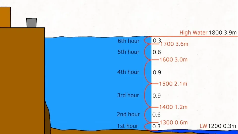
The video is hosted by YouTube (Google): nothing loads until you play it, and Google may then set cookies.
FAQ
What does the tide coefficient mean in France?
It’s a measure of how big the tide is, calculated for the port of Brest and used along every coast of mainland France. It runs from 20 to 120: 45 corresponds to an average neap tide, 95 to an average spring tide, and 120 to an extreme spring tide. The higher it is, the higher the water rises and the lower it drops. It doesn’t give you a height in feet or meters.
How do you use the rule of twelfths?
Divide the duration of the tide, between high and low tide, into six tidal hours, and the tidal range into twelve. Over those six intervals, the water rises or falls by 1, 2, 3, 3, 2, and then 1 twelfth of the range. With a 13.5 ft (4.10 m) range, one twelfth is just over a foot (34 cm): after two tidal hours, the water has moved 3 twelfths, about 3.4 ft (1 m).
When does the tide come in fastest?
At mid-tide. Under the rule of twelfths, the water covers half the tidal range during the third and fourth tidal hours. On a flat shore, it can then cover a lot of ground in very little time. When you go shellfishing, head out on the ebb and be back well before the flood. In an emergency in France, call 196 or 112; in the US, call 911.
Where can I find official tide times?
In France, on SHOM’s website, which publishes tide times for its ports for free. In the UK, on ADMIRALTY EasyTide, from the UK Hydrographic Office; in Germany, on the BSH website; in the United States, on NOAA’s Tides and Currents. These predictions don’t account for the weather, which can shift the water level by something on the order of a foot (a few tens of centimeters).
Sources
- SHOM, Refmar, “Prédiction de marée” fact sheet, May 2024 (in French), accessed October 22, 2026. refmar.shom.fr https://refmar.shom.fr/sites/default/files/2025-01/GT-TSH_CatD_Fiche_Prediction_maree.pdf ↩
- SHOM, Refmar, glossary of the “Tempêtes et submersions historiques” working group (historical storms and coastal flooding), provisional version of July 2024 (in French), accessed October 22, 2026. refmar.shom.fr https://refmar.shom.fr/sites/default/files/2024-07/GT_TSH_Glossaire_Version-provisoire_Juillet2024.pdf ↩
- French Ministry of the Sea, national exam board (Comité national de sélection des sujets), “PNCM 1 2026, CM-3 Navigation, météorologie” exam (in French), accessed October 22, 2026. formations.mer.gouv.fr https://formations.mer.gouv.fr/sites/default/files/2026-07/20247253_PNCM1_CM3.pdf ↩
- Michel Soufflet, “Les marées,” educational paper published by the Publimath digital library (in French), accessed October 22, 2026. bibnum.publimath.fr https://bibnum.publimath.fr/ICA/ICA17004.pdf ↩
- Service-Public.fr, “Quels sont les numéros en cas d’urgence (Samu, pompiers...) et les numéros d’écoute ?,” checked August 25, 2026 (in French), accessed October 22, 2026. service-public.gouv.fr https://www.service-public.gouv.fr/particuliers/vosdroits/F33954 ↩
- SHOM, “Horaires de marées gratuits du SHOM” (in French), accessed October 22, 2026. maree.shom.fr https://maree.shom.fr/ ↩
- SHOM, “Comment calculer les prédictions de marée,” guide to the prediction service for 1,000 ports (in French), accessed October 22, 2026. services.data.shom.fr https://services.data.shom.fr/static/specifications/Notice_1000_ports_SHOM.pdf ↩
- UK Hydrographic Office, “ADMIRALTY EasyTide,” accessed October 22, 2026. easytide.admiralty.co.uk https://easytide.admiralty.co.uk/ ↩
- Bundesamt für Seeschifffahrt und Hydrographie (BSH), “Gezeiten” (in German), accessed October 22, 2026. bsh.de https://www.bsh.de/DE/DATEN/Vorhersagen/Gezeiten/gezeiten_node.html ↩
- NOAA, “Tides and Currents,” accessed October 22, 2026. tidesandcurrents.noaa.gov https://tidesandcurrents.noaa.gov/ ↩
- National Weather Service (NOAA), “Cold Water Hazards and Safety,” accessed October 22, 2026. weather.gov https://www.weather.gov/safety/coldwater ↩

Trail running, snow, water, nature and destinations
Nolwenn covers trail running, snow, water, nature and destinations for Outfarer. Curious about everything, from meteor showers to night-train schedules, she has a knack for digging up the one detail that changes everything, and nailing it in a single sentence.


 Arnaud Couderc
